Cargando...
Recursos educativos
-
Nivel educativo
-
Competencias
-
Tipología
-
Idioma
-
Tipo de medio
-
Tipo de actividad
-
Destinatarios
-
Tipo de audiencia
-
Creador
-

Summaries - The representation of the Earth: maps
EduBook Organización
- 1 lo usan
- 5707 visitas
1. Latitude and longitude Geographical coordinates are imaginary horizontal and vertical lines that encircle the surface of the globe in a grid. There are two types: Parallels: hoirzontally encircle the…
-

Introduction - The representation of the Earth: maps
EduBook Organización
- 3838 visitas
In the past, cartography (or map making) was a very slow process. It involved observation and complex calculations and drawings. Modern maps are made using aerial photos and images from satellites…
-
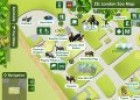
Maps skills: Interactive London zoo map
Maria Pallarés Docente
- 1 lo usan
- 4389 visitas
Students can explore the Zoo of London and find out more about its residents via this interactive map. This resource can be used to introduce some basic features of maps: finding places, orienteering,…
-

Physical Map of Spain - Ezilon Maps
Cristina Seco Organización
- 1 lo usan
- 2442 visitas
Physical map of Spain showing rivers, lakes, elevations and other topographic features. Populated areas are also shown.
-

Mind Mapping Software - Create online Mind Maps
Héctor Espinoza Hernández Docente
- 1 lo usan
- 2463 visitas
Create the best looking mind map online and share it with others. Enjoy mind mapping by brainstorming collaboratively on ideas and projects.
-

Types of maps. Map match activity
Maria Pallarés Docente
- 1 lo usan
- 2721 visitas
This multimedia activity provides students the opportunity to review the different types of maps and do a map match activity to check their knowledge.
-

Mind Mapping Software - Create online Mind Maps
V&V Books Vicens Vives Organización
- 2 lo usan
- 1872 visitas
Create the best looking mind map online and share it with others.
-
Video: Maps, time and world history
Tiching explorer Organización
- 2564 visitas
This video is about the study of world history by examining its use of geographical and chronological frameworks: how they have shaped the understanding of world history and been used to chart the past.
-
Learn. Write a report using maps
EduBook Organización
- 2162 visitas
A report is a written explanation of a topic that has been studied. Reports usually have the following characteristics: The aspects of the topic being analysed are clear. For example, this report is…
-
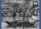
Maps of the Crusades - The Crusades
EduBook Organización
- 2104 visitas
The Crusades is the name of the Christian military expeditions to Jerusalem and the Holy Land.1 There were eight of them between 1096 and 1270. Before the 11th century Christians visited Jerusalem and…


Te estamos redirigiendo a la ficha del libro...
